Physical Address
304 North Cardinal St.
Dorchester Center, MA 02124
Physical Address
304 North Cardinal St.
Dorchester Center, MA 02124

Liberalizing Cities
From The Ground Up
Co-authored with Anthony Ling, editor at Caos Planejado Gentrification Gentrification is the process through which real estate becomes more valuable and, therefore, more expensive. Rising prices displace older residents in favor of transplants with higher incomes. This shouldn’t be confused with the forced removal of citizens via eminent domain or “slum clearance.” Ejecting residents by official fiat is a different problem entirely. A classic example of gentrification is that of Greenwich Village, New York. Affluent residents initially occupied the neighborhood. It later became the city’s center for prostitution, prompting an upper-middle class exodus. Low prices and good location would later attract the textile industry. This was the neighborhood’s first wave of gentrification. But after a large factory fire, the neighborhood was once again abandoned. Failure, however, would give way to unexpected success: artists and galleries began to occupy the vacant factories. These old industrial spaces soon became home to one of the most important movements in modern art. In Greenwich Village, different populations came and went. And in the process they each made lasting contributions to New York’s economic and cultural heritage. This was only possible because change was allowed to take place. But change isn’t always easy. As a neighborhood becomes more popular, it also becomes more expensive. Tensions run high when long-time residents can’t afford rising rents. Some begin to call for rent controls or other measures to prevent demographic churn. But rent control is a temporary fix at best; in the longer term, its effects are negative. By reducing supply, rent control tends to drive up the cost of housing. And in the face of price controls, landlords may seek to exit the rental market entirely, further exacerbating any housing shortage. What, then, does this mean for urban development? How can cities evolve without completely displacing their middle and […]
Want to live in San Francisco? No problem, that’ll be $3,000 (a month)–but only if you act fast. In the last two years, the the cost of housing in San Francisco has increased 47% and shows no signs of stopping. Longtime residents find themselves priced out of town, the most vulnerable of whom end up as far away as Stockton. Some blame techie transplants. After all, every new arrival drives up the rent that much more. And many tech workers command wages that are well above the non-tech average. But labelling the problem a zero sum class struggle is both inaccurate and unproductive. The real problem is an emasculated housing market unable to absorb the new arrivals without shedding older residents. The only solution is to take supply off its leash and finally let it chase after demand. Strangling Supply From 2010 to 2013, San Francisco’s population increased by 32,000 residents. For the same period of time, the city’s housing stock increased by roughly 4,500 units. Why isn’t growth in housing keeping pace with growth in population? It’s not allowed to. San Francisco uses what’s known as discretionary permitting. Even if a project meets all the relevant land use regulations, the Permitting Department can mandate modifications “in the public interest”. There’s also a six month review process during which neighbors can contest the permit based on an entitlement or environmental concern. Neighbors can also file a CEQA lawsuit in state court or even put a project on the ballot for an up or down vote. This process is heavily weighted against new construction. It limits how quickly the housing stock can grow. And as a result, when demand skyrockets so do prices. To remedy this, San Francisco should move from discretionary to as-of-right permitting. In an as-of-right system, it’s much […]

Alain Bertaud is probably the most interesting urbanist you’ve haven’t heard about. He is a senior researcher at the NYU Stern Urbanization Project next to names such as Paul Romer and Solly Angel. Bertaud used to be the lead urbanist at the World Bank, and Ed Glaeser has said that everything he knows about land use restrictions in developing countries he has learned from Alain. Bertaud has also worked as a consultant and/or resident urbanist in cities such as Bangkok, San Salvador, Port-au-Prince, Sana’a, New York, Paris, Tlemcen and Chandigarh. Our Brazilian collaborator Anthony Ling, editor of Caos Planejado, met Bertaud at the NYU DRI conference last year entitled “Cities and Development: Urban Determinants of Success”, who gave us the following interview: AL: You are currently writing a book tentatively titled “Order Without Design”, which in some way relates to the title of our website, “Planned Chaos”. What do you mean by the title of your next book – what should readers expect of it? AB: “Order without design” is a quotation from Hayek that he uses in a different context in “The Fatal Conceit”: “Order generated without design can far outstrip plans men consciously contrive”. In the context of cities it means that cities themselves are mostly self generated by simple rules and norms applied to immediate neighbors but with overall design concept designed by one person or a group of designers. The spatial structure of large cities is a mix of top-down design and spontaneous order created by markets. Spontaneous order appears in the absence of a designer’s intervention when markets and norms regulate relationships between immediate neighbors. Most evolving natural structures, from coral reefs to starlings’ swarms, are created by spontaneous order. The objective of my book is to show that top-down design should be reduced to a minimum and much more room should […]
Alain Bertaud, a senior research scholar at the Urbanization Project, has had a long career in urban planning, and many of his writings have a market urbanist flavor. He is currently working a book called Order Without Design, and last year he published an excerpt from that book called “The Formation of Urban Spatial Structures: Market vs. Design.” In the article he offers a compelling case for letting the market determine building sizes and uses, but he argues that infrastructure provision must be left to the state. I agreed wholeheartedly with the first portion of his paper, but find that his arguments for the market in land use contradict his arguments for the state in infrastructure. Bertaud eloquently explains the knowledge problem facing urban planners who seek to regulate efficient land use patterns. Because economic growth is such a complex process that’s dynamic over time, he explains that top-down design will fail to keep up with changing land use needs to the detriment of economic growth. He cites Hartford, Connecticut as an example. The city developed a large insurance industry, but as it became profitable for American insurance companies to outsource clerical work abroad, fewer Connecticut residents find employment in the industry. However, in a futile effort to maintain jobs, urban planners have refused to update land use regulations to permit new employment opportunities. Rather than succeeding in keeping historical sources of employment in place, urban planners have prevented economic diversity that can hedge against a downturn in a specific industry. Bertaud describes price mechanism that allows the market to identify land’s highest value use: Markets … recycle obsolete land use quasi-automatically through rising and falling prices. This constant land recycling is usually very positive for the longterm welfare of the urban population. In the short term, changes in land use and in the spatial concentration of employment are disorienting and alarming for workers and […]
I noticed an interestingly ironic thing today. The usual argument for the necessity of use-based zoning is that it protects homeowners in residential area from uses that would potentially create negative externalities – ie: smelting factory, garbage dump, or Sriracha factory. Urban Economics teaches us that such an event happening is highly unlikely in today’s marketplace. (nevermind the fact that nuisance laws should resolve these disputes) The business owner who is looking for a site for a stinky business would be foolish to look in a residential area where land costs are significantly higher. However, as Aaron Renn pointed out in the comments of my last post on Planned Manufacturing Districts, the inverse of this is happening in many cities as residential uses begin to outbid other uses in industrial areas: I think part of the rationale in this is that once you allow residential into a manufacturing zone, the new residents will start issuing loud complaints about the byproducts of manufacturing: noise, smells, etc. I know owners of businesses in Chicago who have experienced just that. They’ve been there for decades but now are getting complaints from people who live in residential buildings that didn’t even exist when the manufacturer located there. This puts those businesses under a lot of pressure to leave as officials will almost always side with residents who vote rather than businesses who don’t get to. It’s clear this is a more relevant defense of use-based zoning than the one we usually hear. Of course, I’d argue that segregating uses through zoning isn’t a just way to resolve these disputes, and my last post discusses some of the detrimental consequences for cities. It seems ironic, because it inverts the usual argument in-favor of zoning. Residents are choosing to move near established industrial firms, and PMDs are a tool […]

To someone ignorant of economic reasoning, rent control seems like a great policy. It appears instantly to provide “affordable housing” to poor tenants, while the only apparent downside is a reduction in the income flowing to the fat-cat landlords, people who literally own buildings in major cities and who thus aren’t going to miss that money much. Who could object to such a policy? First, we should define our terms. When a city government imposes rent control, it means the city makes it illegal for landlords to charge tenants rent above a ceiling price. Sometimes that price can vary, but only on specified factors. For the law to have any teeth — and for the politicians who passed it to curry favor with the public — the maximum rent-controlled price will be significantly lower than the free-market price. The most obvious problem is that rent control immediately leads to a shortage of apartments, meaning that there are potential tenants who would love to move into a new place at the going (rent-controlled) rate, but they can’t find any vacancies. At a lower rental price, more tenants will try to rent apartment units, and at a higher rental price, landlords will try to rent out more apartment units. These two claims are specific instances of the law of demand and law of supply, respectively. In an unhampered market, the equilibrium rental price occurs where supply equals demand, and the market rate for an apartment perfectly matches tenants with available units. If the government disrupts this equilibrium by setting a ceiling far below the market-clearing price, then it creates a shortage; that is, more people want to rent apartment units than landlords want to provide. If you’ve lived in a big city, you may have experienced firsthand how difficult it is to […]
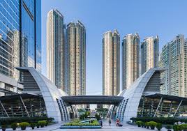
Last week, Nick Josefowitz unseated a multi-decade incumbent for a spot on the BART board of directors. Normally I don’t pay too much attention to elections, but Mr. Josefowitz might actually have some good ideas. For everyone outside the Bay Area, the BART (Bay Area Rapid Transit) system is a commuter rail line that constitutes the vital transportation link between the East Bay and San Francisco. On a typical weekday it provides 400,000 rides and that number is increasing as the regional economy continues to boom. Suffice it to say that BART is a big deal to a lot of people who rely on it every day (myself included). While Josefowitz’s campaign website talks about cleaning up dirty stations and increasing late night train availability, I had the privilege of hearing him outline an interesting proposal during a private, small group discussion some months ago. According to Josefowitz, BART sits on a substantial amount of real estate in the form of station parking lots. His proposal was to repurpose some of this space as high density housing. This would help with the region’s housing shortage and support BART ridership by clustering population around the system’s stations and the lost spots could be offset by building parking structures on the remaining lot space (many BART parking lots are ground level only as opposed to multi-level parking structures). This sounded a lot like Hong Kong’s integrated rail-property development approach which has proven to be an unqualified success, so my interest was definitely piqued. As always, there’s plenty of which to be skeptical. The fact that the proposal was brought up in a private discussion, but isn’t listed on the campaign website may say something about where it falls in Josefowitz’s priorities. Also, it’s difficult to tell how effective the incoming director will be […]
They are called different things in different cities, but they are similar in form and intent among the cities where they are found. For simplicity’s sake, a Planned Manufacturing District (PMD), as they are called in Chicago, is an area of land, defined by zoning, that prohibits residential development and other specific uses with the intent of fostering manufacturing and blue-collar employment. Proponent of PMDs purport to be champions of the middle-class or blue-collar workers, but fail to consider the unintended consequences of prohibiting alternative uses on that land. At best, PMDs have little effect on changing land-use patterns where industrial is already the highest-and-best-use. At worst, they have the long-run potential to distort the land use market, drive up the costs of housing, and prevent vibrant neighborhoods from emerging. A Race to The Bottom Before getting into it further, it is important to examine the economic decisions industrial firms make in comparison to other uses. Earlier in the industrial revolution, industry was heavily reliant on access to resources. Manufacturing and related firms were very sensitive to location. The firms desired locations with easy access to ports, waterways, and later railways to transport raw materials coming in, and products going out. However, the advent of the Interstate Highway System and ubiquitously socialized transportation network have made logistical costs negligible compared to other costs. Where firms once competed for locations with access to logistical hubs and outbid other uses for land near waterways in cities, they now seek locations with the cheapest land where they can have a large, single-floor facility under one roof. This means sizable subsidies must be combined with the artificially cheap land to attract and retain industrial employers on constrained urban sites. Additionally, today’s economy has become much more talent-based rather than resource based, and patterns have shifted accordingly. In contrast to industrial, residential and office uses are […]
Debates over land use policy often devolve into opponents arguing over how to interpret the same set of facts. For example, “market suburbanists” argue that because apartments in walkable neighborhoods tend to cost more per square foot than suburban single family homes, high densities make coastal cities expensive. Smart Growth advocates may look at the same data and argue that zoning rules that restrict the supply of high-density housing in desirable locations is what makes housing expensive. In order to provide clarity to the debate on land use regulations, Mike Lewyn and Kip Jackson survey the zoning codes of the 24 cities with populations between 500,000 and 1,000,000 residents. In their new Mercatus Center study, they find that while some cities have in fact enacted the sorts of policies that market suburbanists fear — minimum density requirements and maximum parking rules — these regulations remain very rare relative to near-ubiquitous maximum density rules and minimum parking requirements. Lewyn and Jackson list the mid-size cities that have adopted various types of Smart Growth regulations below. While a handful of cities have adopted the types of regulations they surveyed, every U.S. city in this sample has a maze of traditional zoning rules. A perpetual challenge in studying the effects of both traditional and Smart Growth regulations is finding data. Municipal codes are all housed on unique websites with varying degrees of accessibility. The difficulty of achieving clear answers as to what causes high housing prices contributes to advocates of traditional zoning and Smart Growth to shout past one another. While Smart Growth as a whole is maligned by some advocates of the free market, many Smart Growth tenets are actually deregulatory. Policy changes including upzoning, reducing parking requirements, and permitting mixed-use development are all steps toward laissez-faire land use relative to the status-quo, even though these policies […]
Integrating rail and property development is the cornerstone of the MTR’s success. In the U.S., coordination between transit authorities and developers tends to be mediocre at best. In Hong Kong, however, the MTR is both the transit authority as well as the property owner, and this makes all the difference. Coordination Problem Most attempts at transit-oriented development in the U.S. involve multi-party negotiations. The agency responsible for the transportation system haggles with different developers interested in undertaking projects along the line. Instead of implementing a unified plan, the transit agency has to negotiate specific agreements with each developer. And, because the priorities of the transit agency and the developers are never perfectly aligned, development agreements become subject to second-best compromises. Further, any disputes that arise once significant capital has been committed are costly to resolve. This arrangement makes leveraging land values difficult as well. Developers frequently get tax breaks as an incentive to undertake projects. Whether abatements on property tax or straight-forward rate reductions, tax incentives typically preclude the use of land values to help fund transit. And, even without special incentives, major property owners who stand to benefit from proximity to a transit system have every reason to resist tax increases of any kind if there’s a chance of free-riding. The MTR, on the other hand, uses the integrated rail-property development approach which combines the two roles of landlord and transit developer. The MTR owns the right-of-way as well as the surrounding properties. This removes the necessity of extended negotiations, having to settle for second best solutions, and the potential downside of disagreements partway through a project. By combining the functions of landlord and transit developer, the MTR is also able to internalize land values. The rail line drives up the value of the MTR’s properties and that value covers […]