Physical Address
304 North Cardinal St.
Dorchester Center, MA 02124
Physical Address
304 North Cardinal St.
Dorchester Center, MA 02124

Liberalizing Cities
From The Ground Up
Maya Dukmasova recently published at Slate an interesting piece about the potential for current trends in affordable housing policy to tear apart the social capital of low-income people. She makes the Ostromian point that policymakers’ lack of understanding of the informal institutions that govern communities makes it likely that government housing policies are likely to have unintended consequences. While Dukmasova aptly characterizes some of the problems with American anti-poverty programs to date, she gets some key history wrong. In particular, she writes: Part of the liberal establishment’s failure to address this problem stems from its inability to embrace truly progressive understandings of poverty. Those advocating for solutions to poverty rarely speak about the way our economy and social infrastructures entrench it. Rather, much of liberals’ efforts have been crippled by unexamined and unchallenged beliefs that the spaces where poor people of color live are morally compromised, beliefs summed up by one well-intentioned but ultimately damaging term: concentrated poverty. In fact, the programs that she criticizes directly grew out of progressive scholarship and politics. Nineteenth century progressives set their sights on demolishing tenements occupied by low-income, immigrant populations with the goal of relocating residents to suburban homes deemed healthier and better for the morals of their inhabitants. Jacob Riis’ influential work in How the Other Half Lives fueled a progressive movement to eradicate tenement housing, with activists motivated both by altruism toward the poor and by a fear of disease and cultural changes that immigrant-dominated neighborhoods brought. Riis became one of the first reformers demanding that “light and air” be a key consideration in new construction. While he used this phrase to campaign against unventilated tenements that actually did create unhealthy indoor conditions indoors, it ultimately provided the policy rationale for the the New York 1916 Zoning Resolution that would limit building height and massing to protect outdoor light and air, as if shade is […]
Last week I wrote a piece for City Journal on how smart parking could allow New York City to implement variable pricing. Street parking sensors allow prices to change to maintain an empty spot on each block, as parking expert Donald Shoup recommends. By eliminating the incentive to drive around looking for parking, this policy could drastically reduce traffic congestion and save drivers significant amounts of time. All of the comments on my post argue that charging for parking according to demand would increase the cost of living in already expensive cities and hurt low-income people. While this argument is very common among supporters of underpriced street parking, it’s false. In actuality, today’s standard policies of underpriced street parking and off-street parking requirements increase costs of living, and low-income people bear a disproportionate share of the costs of these policies. Properly implemented variable pricing systems may not even increase the total price that drivers pay to park their cars. San Francisco has gone farther than any other city to implement variable parking. Its SFPark system updates the prices on the city’s meters periodically with the goal of keeping the occupancy on each block below 80%. While this objective has led to significant price increases for the most in-demand blocks, it has actually reduced the city’s total parking meter revenues because prices were allowed to fall on many blocks to reach the 80% target. Whether they cause total parking meter revenue to increase or decrease, variable parking prices are key to reducing off-street parking requirements, which is a huge cost of development. The political pressure for off-street parking often stems from homeowners who live near commercial destinations. Because people who drive to businesses prefer free parking to paid parking, they may park in a zero-price curb spot in a residential neighborhood near their destination rather than at a […]
The Philadelphia Housing Authority will seize nearly 1,300 properties for a major urban renewal project in the city’s Sharswood neighborhood. The plan includes the demolition of two of the neighborhood’s three high-rise public housing buildings — the Blumberg towers — that will be replaced with a large mixed-income development. The new buildings will increase the neighborhood population tenfold with the majority of the new units to be affordable housing. The majority of the 1,300 lots slated for eminent domain are currently vacant. At a City Council hearing on Tuesday, Philadelphia Housing Authority CEO Kelvin Jeremiah testified that the redevelopment plan furthers the agency’s efforts to replace high-rise housing projects with lower-density units. However, PHA’s plan misses the forest for the trees. The benefits of demolishing the two towers are immediately undone by creating an entire neighborhood of public housing, effectively increasing the concentration of poverty in Sharswood. Adam Lang has lived in Sharswood for 10 years, and he posted about the plan in the Market Urbanism Facebook group. Adam has raised concerns that the PHA does not have an accurate number of how many of the 1,300 properties in the redevelopment territory are currently occupied. Adam’s primary residence is not under threat of eminent domain, however he owns four lots that are. He uses two lots adjacent to his home as his yard. The other two are a shell and a vacant lot. He purchased them, ironically, from the city with the plan to turn them into rentals. Adam’s concern about the inaccuracy of PHA’s vacancy statistics stem from the method that PHA employees used to create their estimate: driving by homes to see if they look occupied or not. Adam’s own property was on the list of vacants, and he said that he’s aware of other properties in the neighborhood […]

There’s a proposal to place a moratorium on all market rate construction in the Mission District, one of San Francisco’s most rapidly gentrifying neighborhoods. Needless to say the proposal has sparked a debate. And Dan Ancona’s Putting Market Fundamentalism On Hold is another rock hurled into that particular fray. But in trying to take the anti-moratorium/pro-supply camp to task, it falls into the same unproductive bomb hurling we’ve been watching now for years. The following are a few thoughts on some of the points Mr. Ancona makes in his recent piece. Talking Past Each Other The first point is about a fundamental misunderstanding of the motivations behind the moratorium. Mr. Ancona makes this mistake, but so do the exasperated anti-moratorium/pro-supply advocates he quotes at the beginning of his piece. Hint: The moratorium is not about lowering housing prices. To be sure, the anti-moratorium camp wants lower aggregate housing prices throughout San Francisco and the entire region. The indisputable way to accomplish this goal is by building more housing. And as far as the anti-moratorium camp is concerned, this includes plenty of below market rate (BMR) construction to mitigate some of the distributional effects of development. For the pro-moratorium camp, however, this doesn’t cut it. Lower aggregate prices are not their goal. Their goal is keeping the existing population of the Mission intact and in place. Even a 70/30 ratio of market rate development to BMR construction wouldn’t do that. There would still be demographic churn and this is specifically what they want to avoid. For the pro-moratorium camp, lower housing prices are all well and good, but not if that means the dispersal of the existing community in the process. Searching for the Endgame The second issue is that there’s no endgame for the pro-moratorium camp. Mr. Ancona seems to think there is, but doesn’t go […]
“How to Make an Attractive City”, a video by The School of Life, recently gained attention in social media. Well presented and pretty much aligned with today’s mainstream urbanism, the video earned plenty of shares and few critiques. This is probably the first critique you may read. The video is divided into six parts, each with ideas the author suggests are important to make an attractive city. I will cover each one of them separately and analyze the author’s conclusion in a final section. 1 – Not too chaotic, not too ordered The author argues that a city must establish simple rules to to give aesthetic order to a city without producing excessive uniformity. From Alain Bertaud’s and Paul Romer’s ideas, it can make sense to maintain a certain order of basic infrastructure planning in to enable more freedom to build in private lots. However, this is not the order to which the video refers, suggesting rules on the architectural form of buildings. The main premise behind this is that it “is what humans love”. But though the producers of the video certainly do love this kind of result, it is impossible to affirm that all humans love a certain type of urban aesthetics generated by an urbanist. It is even less convincing when this rule will impact density by restricting built area of a certain lot of land or even raising building costs, two probable consequences of this kind of policy: a specific kind of beauty does not come for free. Jane Jacobs, one of the most celebrated and influential urbanists of the modern era, clearly argued that “To approach a city, or even a city neighborhood, as if it were a larger architectural problem, capable of being given order by converting it into a disciplined work of art, […]
Seamless Transit is the new transportation policy report from SPUR. Main author Ratna Amin proposes integrating the Bay Area’s balkanized transit systems to improve lackluster ridership. Given that the region has 23 separate transit providers–more than any other metropolitan area in the country–she may have a point. The report proposes standardizing service maps, fare structures, and payment systems; eliminating inter-system coverage gaps as well as redundant coverage; and reforming transit governance so that the different agencies actually make plans together instead of working at cross-purposes or not at all. The recommendations are sound and the report includes historical footnotes for context. These are helpful for understanding region’s complicated institutional arrangements. Seamless Transit is a fine piece of work and well worth the read for anyone interested in Bay Area transportation. But while organizational efficiency is important, it’s not the only thing to discuss. If we want to improve the region’s mass transit systems, we have to consider the physical environment in which those systems are embedded. To get transit right, the region needs to embrace density. Denser development around transit nodes would increase ridership substantially. When people live, work, and play in smaller geographic areas, more people travel between a fewer number of points. Mass transit, especially fixed rail transit, becomes more effective the denser development becomes. Hong Kong’s Metro Transit Railway (MTR) might be the quintessential example of urban density begetting mass transit success. The city is home to over 7 million inhabitants. It has a population density of over 18,000 residents per square mile. And of this population, 41% live within a half mile of an MTR station. The result? The MTR has a farebox recovery ratio of 186%–the highest in the world. Because of legal as well as political differences between Hong Kong and the Bay Area, […]

Housing has a lot going against it in the California. But amidst all the legal, political, and regulatory roadblocks, there’s one law that sneaks by largely unnoticed: Prop 98. Prop 98 guarantees a minimum level of state spending on education each year. Sacramento pools most city, county, and special district property taxes into special education funds to meet this commitment. The localities only get to keep a small part of the property tax revenues for their own general budgets. This system creates a disincentive for cities to permit housing. New housing brings in new residents who need city services. But it doesn’t bring in a commensurate increase in property taxes since most of that revenue gets scooped up by Sacramento. Commercial development, though, brings in taxes a city gets to keep. Sales and hotel taxes are significant revenue streams. And they don’t cause the kinds of strain on city services that new residential does. Reforming Prop 98 might be low hanging fruit. Changing the formula to appropriate a broader stream of city revenues might help ease the bias against housing. And it might even be possible to amend the law without having to fight the California Teachers Association. As long as there’s no net decrease in education funding, of course. It’s tough to say exactly how much new housing Prop 98 actually prevents. Different cities get to keep different amounts of their property taxes, so the disincentive differs case to case. And there are plenty of other things like CEQA and Prop 13 which put a drag on new construction as well. But where CEQA and Prop 13 make it easier for residents who are already NIMBYs to gum up the works, Prop 98 is a reason in itself for a city to avoid residential development. So while we can’t do […]

Over at Greater Greater Washington, Ms. Cheryl Cort attempts to temper expectations of what she calls the “libertarian view (a more right-leaning view in our region)” on affordable housing. It is certainly reassuring to see the cosmopolitan left and the pro-market right begin to warm to the benefits of liberalization of land-use. Land-use is one area the “right,” in it’s fear of change, has failed to embrace a widespread pro-market stance. Meanwhile, many urban-dwellers who consider themselves on the “left” unknowingly display an anti-outsider mentality typically attributed to the right’s stance on immigration. Unfortunately, in failing to grasp the enormity of the bipartisan-caused distortion of the housing market, Ms. Cort resigns to advocate solutions that fail to deliver widespread housing affordability. Yes, adding more housing must absolutely be a part of the strategy to make housing more affordable. And zoning changes to allow people to build taller and more usable space near transit, rent out carriage houses, and avoid expensive and often-unnecessary parking are all steps in the right direction. But some proponents go on to say relaxing zoning will solve the problem all on its own. It won’t. Well, if “relaxing” zoning is the solution at hand, she may be right – relaxing will only help a tad… While keenly aware of the high prices many are willing to pay, Cort does not seem to grasp the incredible degree to which development is inhibited by zoning. “Relaxing” won’t do the trick in a city where prices are high enough to justify skyscrapers with four to ten times the density currently allowed. When considering a supply cap that only allows a fraction of what the market demands, one can not reasonably conclude “Unlimited FAR” (building density) would merely result in a bit more development here and there. A radically liberalized land-use regime would […]
This post draws heavily from Tom W. Bell’s “Want to Own a City?” and would not have been possible without his prior writing and research The “Right to the City” is an old marxist slogan that’s as catchy as it is ill-defined. Neither the phrase’s originator Henri Lefebvre, nor David Harvey, a more recent proponent, seem to have articulated the idea in any meaningful way. Even the Right to the City Alliance stops short of explaining what the right actually is. When it comes up, it’s typically alongside a claim that something is being stolen or taken away from long-standing communities, as if neighborhoods were sovereign territory suffering from an invasion. For practical purposes, no one has any right to reside in any place beyond their ability to pay. But if the desire is for a way in which communities could actually own the places they call home, perhaps the Right to the City should be a property right. Public Ownership through Private Property What’s the difference between a private company and a municipal corporation? You can own the former but not the latter. Investors have clearly delineated property rights in their corporations. Residents have no equivalent ownership rights in their cities. But what if living in a city meant owning a piece of it as a legal entity as well? Imagine that a city issued shares to its residents. Shares would vest over time and long-time residents would have more equity than new arrivals. Now assume that this city took in all of its revenue through land value taxation and that land revenues were used to pay dividends to the city’s resident-shareholders. Instead of facing displacement, incumbent residents would benefit from rising demand to live in their city. Shares might also be used to weight the voting system. More shares could […]
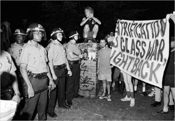
Gentrification is the result of powerful economic forces. Those who misunderstand the nature of the economic forces at play, risk misdirecting those forces. Misdirection can exasperate city-wide displacement. Before discussing solutions to fighting gentrification, it is important to accept that gentrification is one symptom of a larger problem. Anti-capitalists often portray gentrification as class war. Often, they paint the archetypal greedy developer as the culprit. As asserted in jacobin magazine: Gentrification has always been a top-down affair, not a spontaneous hipster influx, orchestrated by the real estate developers and investors who pull the strings of city policy, with individual home-buyers deployed in mopping up operations. Is Gentrification a Class War? In a way, yes. But the typical class analysis mistakes the symptom for the cause. The finger gets pointed at the wrong rich people. There is no grand conspiracy concocted by real estate developers, though it’s not surprising it seems that way. Real estate developers would be happy to build in already expensive neighborhoods. Here, demand is stable and predictable. They don’t for a simple reason: they are not allowed to. Take Chicago’s Lincoln Park for example. Daniel Hertz points out that the number of housing units in Lincoln Park actually decreased 4.1% since 2000. The neighborhood hasn’t allowed a single unit of affordable housing to be developed in 35 years. The affluent residents of Lincoln Park like their neighborhood the way it is, and have the political clout to keep it that way. Given that development projects are blocked in upper class neighborhoods, developers seek out alternatives. Here’s where “pulling the strings” is a viable strategy for developers. Politicians are far more willing to upzone working class neighborhoods. These communities are far less influential and have far fewer resources with which to fight back. Rich, entitled, white areas get down-zoned. Less-affluent, disempowered, minority […]