Physical Address
304 North Cardinal St.
Dorchester Center, MA 02124
Physical Address
304 North Cardinal St.
Dorchester Center, MA 02124

Liberalizing Cities
From The Ground Up
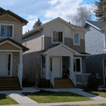
One common argument against tall buildings is that they reduce street life, because the most expensive high-rises have gyms and other amenities that cause people to stay inside the buildings rather than using the street. Because Manhattan has plenty of high-rises and plenty of street life, I have always thought this was a dumb argument. But until recently I’ve never thought of any way to prove or disprove the argument empirically- until now. It seems to me that if high-rises were bad for street life, places with expensive high-rises would have lower Walkscores than other neighborhoods; I reason that if high-rise residents stayed inside rather than going outside, they would be surrounded by fewer businesses than low-rise neighborhoods. So do high-rises generally have lower Walkscores? Not in dense areas; for example, 432 Park Avenue, one of Manhattan’s most expensive buildings, has a Walkscore of 98. Similarly, Boston’s Millenium Tower, a 60-story residential skyscraper, has a Walkscore of 96.
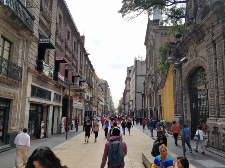
This piece was coauthored by Nolan Gray and Katarina Hall. It’s like Los Angeles, but worse. To many, that’s the mental image of Mexico City: a city of unending traffic, unbearable smog, and unrestrained horizontal expansion. Yet when one walks the streets of Mexico City, a distinct reality comes into view: a city of wide sidewalks and integrated bike lanes, lush parks and cool street tree canopies, and dense, mixed-use urban neighborhoods. As a matter of fact, nearly every neighborhood within Mexico City’s giant ring road—the Circuito Interior—has a walkscore above 95. Many major U.S. cities lack even one neighborhood with such a high score. Even on the outer fringe of Mexico’s sprawling Distrito Federal, neighborhoods often have walkscores upwards of 70, qualifying as “very walkable.” What makes Mexico City so walkable? The first thing an American might notice about Mexico City is just how busy the city’s sidewalks are. It’s a city of 21,339,781, and it shows. But this busyness isn’t a mere side-effect of size; it’s a natural result of the city’s generous sidewalks and high-quality pedestrian infrastructure. Many downtown roads host spacious sidewalks, accommodating an unending sidewalk ballet of commuters, tourists, and street vendors. Wide medians along major boulevards offer both refuge for crossing pedestrians and a public space in which people are encouraged to meet and relax. Many of the city’s busiest downtown areas have been closed to automobile traffic. Mexico City’s main road—Paseo de la Reforma—is reserved on Sundays for pedestrians and cyclists. “Jaywalking” is normal and in many cases is assisted by traffic police—a stark contrast to the near persecution pedestrians often face in U.S. cities. The ample space for pedestrians attracts not only foot traffic but also the people watchers who come to enjoy the vitality, in turn keeping many downtown […]
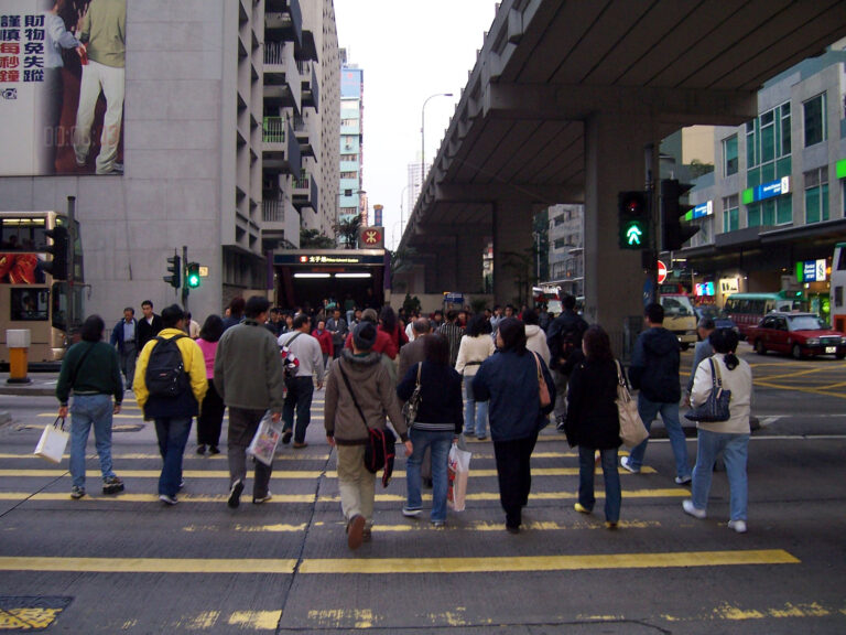
Last week DC Streetsblog reported on a new survey from Kaiser Permanente. The survey covers Americans’ attitudes toward walking and their self-reported walking habits. While a substantial majority of people believe that walking has health benefits ranging from weight management to alleviating depression, the survey found that most people walk less than the 150 minutes per week that the Centers for Disease Control and Prevention recommends. The Streetsblog coverage attributes a lack of walkable infrastructure to low walking rates, although it’s not clear to me that the survey explicitly supports this conclusion. However, past research demonstrates that people who live in neighborhoods where they are able to complete errands on foot do, unsurprisingly, do walk more than those who don’t. While people may not cite walkabilty as an important consideration in choosing a house, choosing a home involves weighing many factors, from size, price, distance to work and other amenities, aesthetic, and countless others factors. Consumers rely on tacit knowledge to weigh many of these factors because they can’t consciously enumerate all of them in making a decision of where to live. For this reason, revealed preference theory is a more reliable tool than survey data for observing how consumers value one attribute of a complex good like housing. Building on a past project, my colleague Eli Dourado and I are studying whether or not consumers do pay a premium for greater neighborhood walkability. Using a fixed-effects model, across all metropolitan and micropolitan statistical areas in the United States, our preliminary results indicate that, on average, Americans are willing to pay a premium of about $850 for a house with one additional point in Walk Score. Because of the many restrictions that limit walkable development, consumers have to pay this premium for the scarce supply of houses in walkable neighborhoods. This finding […]
I recently googled upon a post at a blog called “Rub-a-Dub” that mentioned a land development project in Mount Pleasant, SC called I’On. I imagine the developers of the I’On “Traditional Neighborhood Development” (TND) community are sympathetic with Market Urbanism, as they named streets after John Galt (of Ayn Rand’s Atlas Shrugged), free-market economists Ludwig Von Mises and Thomas Sowell, as well as urbanist writer Jane Jacobs. (ironically, Jane Jacobs Street doesn’t have sidewalks) Who says New Urbanists and free markets can’t mix? (well, I’m sure we all can name at least one such person…) What I found interesting was the story of the development shared in the comments of the post by Vince Graham, Founder and President of the development company. The story really conveyes the struggles developers go through to get projects through the approval process; especially when the standard 20th century, auto-centric layout is being challenged by innovative development solutions. The reason why there is only single family homes and a limited amount of commercial space in the neighborhood is due to unfortunate compromises necessary to get the neighborhood approved through the arduous political process. Here is a summary: A Summary of the Political Background and Permitting History for I’On. Background:The traditional walking neighborhood of I’On is located on a 243-acre infill site in Mt. Pleasant, SC located 5 miles from Charleston’s historic district and 3 miles from the Old Village of Mt. Pleasant. The site is surrounded by conventional subdivision development of the 1950’s, 60’s, 70’s, and 80’s. Approximately 60% of I’On’s acreage was originally comprised of former agricultural fields, 30% was 30-40 year old hard wood growth, and 10% took the form of three man made lakes. The design workshop for I’On took place in May of 1995. I’On received approval in March of […]
I related to this particular post by Michael Lewyn at Planetizen, Why I fight: Occasionally, someone familiar with my scholarship asks me: why do you care about walkability and sprawl and cities? Why is this cause more important to you than twenty other worthy causes you might be involved in? The answer: Freedom. Now, the article doesn’t discuss freedom from a property rights or free-market point of view, but from a mobility point of view. As a former “carless teenager” in suburbia (well, carless until 16), I can relate to that. I think my yearning for freedom is what sparked my interest in the city too. Of course, some people equate driving to freedom. For some its walkability, transit, or silent star filled skies. Freedom means different things to everyone, and I found my freedom in the diverse experiences and opportunities only available in the city.
A recent Wall Street Journal blog post refers to a website called Walk Score. Walk Score will let you know the walkability of a neighborhood based on the address you type in. The site also features ranking of cities and neighborhoods. Here are the city rankings: 1. San Francisco, CA 2. New York, NY 3. Boston, MA 4. Chicago, IL 5. Philadelphia, PA 6. Seattle, WA 7. Washington D.C. 8. Long Beach, CA 9. Los Angeles, CA 10.Portland, OR I assume San Francisco beat New York, because New York City includes the less walkable areas such as Staten Island. I can brag that I have lived in 3 of the top 4 most walkable cities: New York, Chicago, and Boston. (although I actually lived right accross the river in Cambridge, which I think still counts) I was also pleasantly surprised at how many of Milwaukee’s neighborhoods ranked above 90. How It Works Walk Score helps people find walkable places to live. Walk Score calculates the walkability of an address by locating nearby stores, restaurants, schools, parks, etc. Walk Score measures how easy it is to live a car-lite lifestyle—not how pretty the area is for walking. What does my score mean? Your Walk Score is a number between 0 and 100. Here are general guidelines for interpreting your score: 90–100 = Walkers’ Paradise: Most errands can be accomplished on foot and many people get by without owning a car. 70–89 = Very Walkable: It’s possible to get by without owning a car. 50–69 = Somewhat Walkable: Some stores and amenities are within walking distance, but many everyday trips still require a bike, public transportation, or car. 25–49 = Car-Dependent: Only a few destinations are within easy walking range. For most errands, driving or public transportation is a must. 0–24 = […]