Physical Address
304 North Cardinal St.
Dorchester Center, MA 02124
Physical Address
304 North Cardinal St.
Dorchester Center, MA 02124

Liberalizing Cities
From The Ground Up
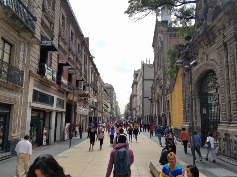
This piece was coauthored by Nolan Gray and Katarina Hall. It’s like Los Angeles, but worse. To many, that’s the mental image of Mexico City: a city of unending traffic, unbearable smog, and unrestrained horizontal expansion. Yet when one walks the streets of Mexico City, a distinct reality comes into view: a city of wide sidewalks and integrated bike lanes, lush parks and cool street tree canopies, and dense, mixed-use urban neighborhoods. As a matter of fact, nearly every neighborhood within Mexico City’s giant ring road—the Circuito Interior—has a walkscore above 95. Many major U.S. cities lack even one neighborhood with such a high score. Even on the outer fringe of Mexico’s sprawling Distrito Federal, neighborhoods often have walkscores upwards of 70, qualifying as “very walkable.” What makes Mexico City so walkable? The first thing an American might notice about Mexico City is just how busy the city’s sidewalks are. It’s a city of 21,339,781, and it shows. But this busyness isn’t a mere side-effect of size; it’s a natural result of the city’s generous sidewalks and high-quality pedestrian infrastructure. Many downtown roads host spacious sidewalks, accommodating an unending sidewalk ballet of commuters, tourists, and street vendors. Wide medians along major boulevards offer both refuge for crossing pedestrians and a public space in which people are encouraged to meet and relax. Many of the city’s busiest downtown areas have been closed to automobile traffic. Mexico City’s main road—Paseo de la Reforma—is reserved on Sundays for pedestrians and cyclists. “Jaywalking” is normal and in many cases is assisted by traffic police—a stark contrast to the near persecution pedestrians often face in U.S. cities. The ample space for pedestrians attracts not only foot traffic but also the people watchers who come to enjoy the vitality, in turn keeping many downtown […]
Old Urbanist is one of my favorite urbanist blogs (and not just because of the name), and Charlie’s got a post up about Boston that I think has a good market urbanist lesson in it. He describes how the formerly elevated Central Artery, buried by the Big Dig, was replaced with a park, with nobody seeming to understand that highways’ damaging effects comes from what they demolish – buildings, and lots of them. An excerpt: With no one able to agree on anything in particular, the environmentalists of the late 1980s stepped in to offer the compelling alternative of nothing, packaged under the name “open space,” and obtained a requirement that 75% of the land above the buried highway be set aside for it. The realization has only recently sunk in that even “nothing” must be paid for, as the conservancy tasked with maintaining the Greenway has now proposed taxing abutting property owners to raise funds, the largesse of Boston’s citizens, already maintaining several very large parks in close proximity, apparently falling short. Thus, land that, under private ownership, might have provided millions of dollars in tax revenue to the city, and hosted thousands of jobs and apartments, has become a money pit. The missed opportunity is even more tragic given that one of the very few neighborhoods in the United States laid out in truly traditional fashion, the North End, with its narrow winding streets and attractive mid-rise architecture, sits right next to the Greenway. The blank side walls of 19th century townhouses, their adjoining buildings demolished for the Artery in the 1950s, cry out to be extended southwards by new neighbors. The elusive vision is right there, a reality, not a fantasy, yet somehow it escaped the attention of Boston’s elected officials, planners, architects and the public itself. […]