Physical Address
304 North Cardinal St.
Dorchester Center, MA 02124
Physical Address
304 North Cardinal St.
Dorchester Center, MA 02124

Liberalizing Cities
From The Ground Up
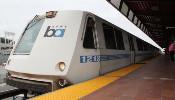
On August 23rd, a California assembly bill aimed at increasing transit-oriented development, like housing, was passed by the state senate, confirmed by the assembly, and headed to Governor Jerry Brown’s desk for signing. The bill, AB 2923, specifically targets the San Francisco Bay Area—making it easier than ever for the Bay Area Rapid Transit (BART) to build housing on the land it owns around its transit stations. Previously, housing developments on BART-owned land were still subject to local zoning rules, pushing projects through local processes to be approved before building began. This local control led to many delays, and, as a result, housing denials in the midst of an ongoing housing shortage—on that repeatedly spurs news headlines decrying four-plus hour super commutes, median home prices over $1 million, and neighborhoods blocking affordable housing. State bills like AB 2923 are a response to these reports, as well as the local control that led to them. If passed, AB 2923 and other bills like it, will bypass local control’s draconian rules to allow more housing to be built and ease the housing shortage. Under current law, land owned by BART is often subject to discretionary review in Bay Area cities. This forces BART to become de facto experts in every municipality zoning code, an impossible task that would take away from their focus on improving their transit system. Even attempting to master the zoning codes of every municipality takes time. Ultimately, this causes delays in building housing that’s so sorely needed. But this could easily be avoided if BART could establish their own zoning rules under AB 2923. Housing and transit is intrinsically linked and, just like suburban home developers build the roads to best suit their development, urban transit authorities like BART must utilize their capacity to build the homes best […]
A recent headline in the Forbes blog screams: “Additional Housing Won’t Make City More Affordable, Says Fed Study.” This blog post cites a Federal Reserve Study showing that adding 5 percent more housing in the most desirable urban neighborhoods would lower rents by only 0.5 percent. But if you read the study more carefully, it doesn’t stand for what the headline says it stands for. First of all, it refers only to increasing housing supply in the most expensive neighborhoods. But housing markets are citywide- so of course if you increase housing supply in just one or two neighborhoods, you are not going to get significant rent reductions. If you raised housing supply by 5 percent everywhere, presumably you would get more than a 0.5 percent rent reduction. The study itself states: ” The papers that find large effects of regulation on house prices are not necessarily at odds with our findings in this paper, because regulations can have very large effects on the housing stock. For example, Jackson (2016) finds that an additional regulation reduces residential permits by 4 to 8 percent per year. Glaeser and Ward (2009) estimate even larger effects on supply. These effects on construction can accumulate into very large changes to the housing stock, especially when these regulations are in place for many years, as is often the case.” (p. 5) In other words, the study admits that supply-limiting regulations do affect housing costs: precisely the opposite of what a careless reader might think from reading the Forbes headline. Second of all, 5 percent is not exactly a huge increase. Even the author of the Forbes blog post concedes that more aggressive supply increases might lead to more aggressive rent reductions. Third, the study assumes a zero vacancy rate (p. 13) which seems to be an assumption that […]
A pure libertarian might argue that in an ideal world, there’d be no need for government-subsidized housing for low- and moderate-income households. Nevertheless, it seems to me that in the world we actually live in, even people generally opposed to the welfare state should favor more such housing. This is so for several reasons. First, government raises the cost of housing through a wide variety of regulations- some justified (e.g. building codes necessary for safety), some not-so-justified (e.g. exclusionary zoning). These regulations, by raising the cost of housing, effectively take money from all households. And because these restrictions aren’t based on ability to pay, they are especially painful for low-income households. Public housing and similar programs, rather than being a subsidy to the undeserving poor, are merely compensation for this act of plunder. Second, even if the United States abolished zoning tomorrow, it might take decades for housing supply to increase enough to bring rents down. So in the interim, lower-income households would still be suffering from the effects of zoning, and would deserve compensation just as much as they do under the status quo. Third, even if the United States abolished zoning and similar restrictions tomorrow, public health and safety might support certain restrictions that nevertheless increase the cost of housing- for example, some basic safety protections in building codes. It seems to me that as a matter of justice, government should not be forcing people into homelessness, so government should subsidize housing in order to make up for the costs imposed by even the most legitimate regulations. Finally, even if there were no housing-related regulations at all, the cost of land would create a floor under housing costs, which means some people would be homeless without government support. So if homelessness creates harmful social externalities of any kind, […]

On June 24 in Brooklyn, a driver in an SUV struck and killed four-year-old Luz Gonzalez, with many onlookers claiming the incident was a hit-and-run. The New York Police Department disagrees, and has refused to prosecute the driver, sparking multiple street protests. Beyond seeking justice for Gonzalez, activists demand that the city expand the use of speed cameras in school zones, which they hope could prevent further tragedy. Yet precisely at the moment that the community is most sensitive to the risk that dangerous driving poses to children, the New York state legislature shut off 140 school zone speed cameras. Given their unambiguous success in improving traffic safety in school zones, legislators should act now to renew and expand the program. While there is rare consensus among Governor Andrew Cuomo and Mayor Bill de Blasio on the need to preserve and even expand the traffic camera program to 290 cameras, the expansion faces opposition from some members in the Senate. Opposition to the cameras has been lead by Republican State Senator Martin J. Golden—himself a notorious school zone speeder, having received over 10 tickets since 2015 alone—and Democrat State Senator Simcha Felder, who ineffectively used the cameras as a bargaining chip to install police officers in schools. Since their implementation in 2014 as part of the broader Vision Zero initiative, school zone speed cameras have already substantially improved pedestrian safety in New York’s school zones. According to one study by the New York City Department of Transportation, the number of people killed or seriously injured in crashes in schools zones has fallen by 21 percent to 142 since the cameras came online. This is due in part to the fact that speeding drivers are getting the message: in the first 14 months following implementation of cameras, speeding violations in school […]
Here’s something I hadn’t thought of in quite this way (but many others probably have): In a living city, space is cheap enough so that people with wacky (often “terrible”) new ideas can test them out, while wealthier people in that city search for wacky new things to try out (because they’ve experienced a lot of other things). In “creative” markets, such as for art, the demand side complements the supply side across income groups in an interesting way.

At first blush, the enterprise of interpreting the Jane Jacobs’ work might seem like one best left to the proud and peculiar few, or to put it less charitably, those of us with nothing better to do. Yet the forces of history militate against this apathy: Jane Jacobs has emerged as quite possibly the most important figure in North American urban planning in the second half of the twentieth century. Her work is now taught in every urban theory and urban planning program worth its weight in ESRI access codes. She is responsible for introducing hundreds of thousands of people to planning and urbanism (including this author) and continues to shape how many of us think about cities. In one of my more popular blog posts here on Market Urbanism—and in a forthcoming book chapter—I argue that we should interpret Jane Jacobs as a spontaneous order theorist in the tradition of Adam Smith, Michael Polanyi, and F.A. Hayek. Built into her work is a profound appreciation of the importance of local knowledge, decentralized planning, and the spontaneous orders that structure urban life. Needless to say, this is not the prevailing interpretation of the importance and meaning of Jacobs’ work. Two very different alternative interpretations prevail. In this post, I argue that both interpretations are mistaken. Jane Jacobs, Form-Based Coder Many have taken Jacobs’ particular critiques of conventional U.S. zoning, often referred to as “Euclidean zoning,” as motivating a new form of zoning that takes into account her observations on design. In contrast to the mandates of Euclidean zoning, which proscribes land-use segregation and low densities, Jacobs celebrated mixtures of land uses and urban densities. Jacobs spends large sections of Death and Life discussing in detail particular urban designs that she sees as essential to fostering urban life. Much of “Part One” focuses on […]

There’s been an ongoing debate in urbanist circles about whether autonomous vehicles (AVs) will damn us to perpetual sprawl and super commuting. I don’t believe that they will. In the first place, the business conditions under which AVs could conceivably induce more sprawl are unlikely. And in the second, there are numerous other factors that will affect the future of urban development in the US. That’s not to say we won’t double down on past mistakes, but it won’t be AVs that single handedly bring about that future on their own. No One Wants To Sell You a Self Driving Car For AVs to even begin to induce more sprawl, they need to facilitate super commuting. For that to happen at any significant scale, they need to be ubiquitous and privately owned. And that is something I don’t think we’re going to see for one simple reason — it’s a product no one is selling. Ole Muskie notwithstanding, no one with capital to burn thinks selling private AVs is a winning strategy (with good reason). Given the accumulated R&D costs of the last several years, the price a firm would need to charge for the first generation of personal AVs would be astronomical. Moreover, a company selling personal AVs would give up on mountains of valuable data generated as the vehicle racked up mileage. Trip data feeds back in to improving the ability of AVs to navigate and data about consumer habits is valuable as well. We should also remember that the state of AV technology is still quite…meh. And in the absence of a step function improvement in the technology, the fastest way to get to market is to restrict the problem space. That means means a driverless TNC service that can be limited to trips in certain areas […]
I found an interesting new website: EvictionLab. This website contains eviction data by city for a large number of American communities. One might think that gentrifying cities and/or high cost cities have more evictions. But interestingly, low-cost, poor cities tend to have more evictions. Nine of the ten cities with the highest eviction rates are in low-cost southern states; the tenth is Warren, Michigan. Even within states, low-cost cities tend to have higher eviction rates than more expensive, gentrifying cities. For example, Fresno has the highest eviction rate of any major city in California- 2.8 (that is, 2.8 evictions for every 100 renter households) while Los Angeles and San Francisco are below 0.5. Seattle has a lower eviction rate (0.3) than Washington’s smaller cities, Austin has a lower eviction rate than Dallas or Houston (0.98 percent as opposed to over 1.5 percent for Houston and Dallas). Miami’s 2.01 percent eviction rate, although high by national standards, is lower than that of other Florida cities such as Jacksonville (5.34) and Tampa (3). New Orleans (1.6) has a lower eviction rate than Baton Rouge and Shreveport (both of which clock in at over 4 percent). New York City is a partial exception- its 1.61 rate is higher than that of Syracuse and Yonkers; on the other hand no statistics are available for the state’s two biggest cheaper cities, Buffalo and Rochester. So what does it all mean? It seems clear that there is not a strong correlation between gentrification and eviction, or for that matter between higher-than-average housing costs and eviction. Beyond that, I’m not sure what conclusions to draw.

How much should we blame planning for the degree to which cities sprawl? As much time as we (justifiably) spend here on this blog explaining how conventional U.S. planning drives excessive sprawl, it’s worth periodically remembering that, at the end of the day, the actual extent of the horizontal expansion of cities is largely outside the control of urban planning. Consider Houston. Whenever I say anything nice about Houston’s relatively liberal approach to land-use regulation, someone invariably comments some variation of the following: “Yes, that’s all well and good in theory. But in practice, heavily regulated cities like Boston are far more urban and walkable, so maybe relaxed land-use regulations aren’t so great.” Indeed, most of Houston is classic sprawl. But this begs the question: to what extent can urban planning policy be blamed for sprawl? The urban economist Jan Brueckner, drawing on an extensive literature, distinguishes between the “fundamental forces” that naturally drive urban growth outward and the market failures that push this growth beyond what might occur in an appropriately regulated market. (For the purposes of this post, I’ll be using “sprawl” and “horizontal urban expansion” interchangeably. In the same paper, Brueckner thoughtfully distinguishes the two.) The latter, urban planners can address. The former, not so much. Let’s look first at the “fundamental” variables that planners have little to no control over. Brueckner identifies three: population growth, rising income, and falling commuting costs. The first variable is obvious: as cities grow, demand for all housing goes up, and some of that housing goes out on the periphery regardless of planning policy. Metropolises like Houston, Dallas, and Atlanta are currently experiencing 2% population growth every year, meaning they are on track to double in population in the next 35 years. You would expect a lot of horizontal expansion, all else […]
I recently discovered a new logical fallacy: the “Morton’s Fork” fallacy. This argument is one in which contradictory observations lead to the same conclusion. For example, if I argue that new housing near public transit is bad because it (1) spurs gentrification by bringing rich people into the neighborhood and (2) increases crime by bringing poor people into the neighborhood, I am engaging in this fallacy. Similarly, I have heard arguments that new housing is bad because it (1) brings down property values and (2) increases property values. In such situations, it is sometimes possible that one of the two claims could be true, but it is unlikely that both claims could be true.